Discover Our Historic Map Range
Count on our Historic Map range for reliability and premium quality.
National Geographic: Europe 1915 World War 1 - Historic Wall Map Series - 31.5 x 28.5 inches - Paper Rolled
Historic Pictoric World War II map. by Stanley Turner, 1943 - Vintage Wall Art - 24in x 16in
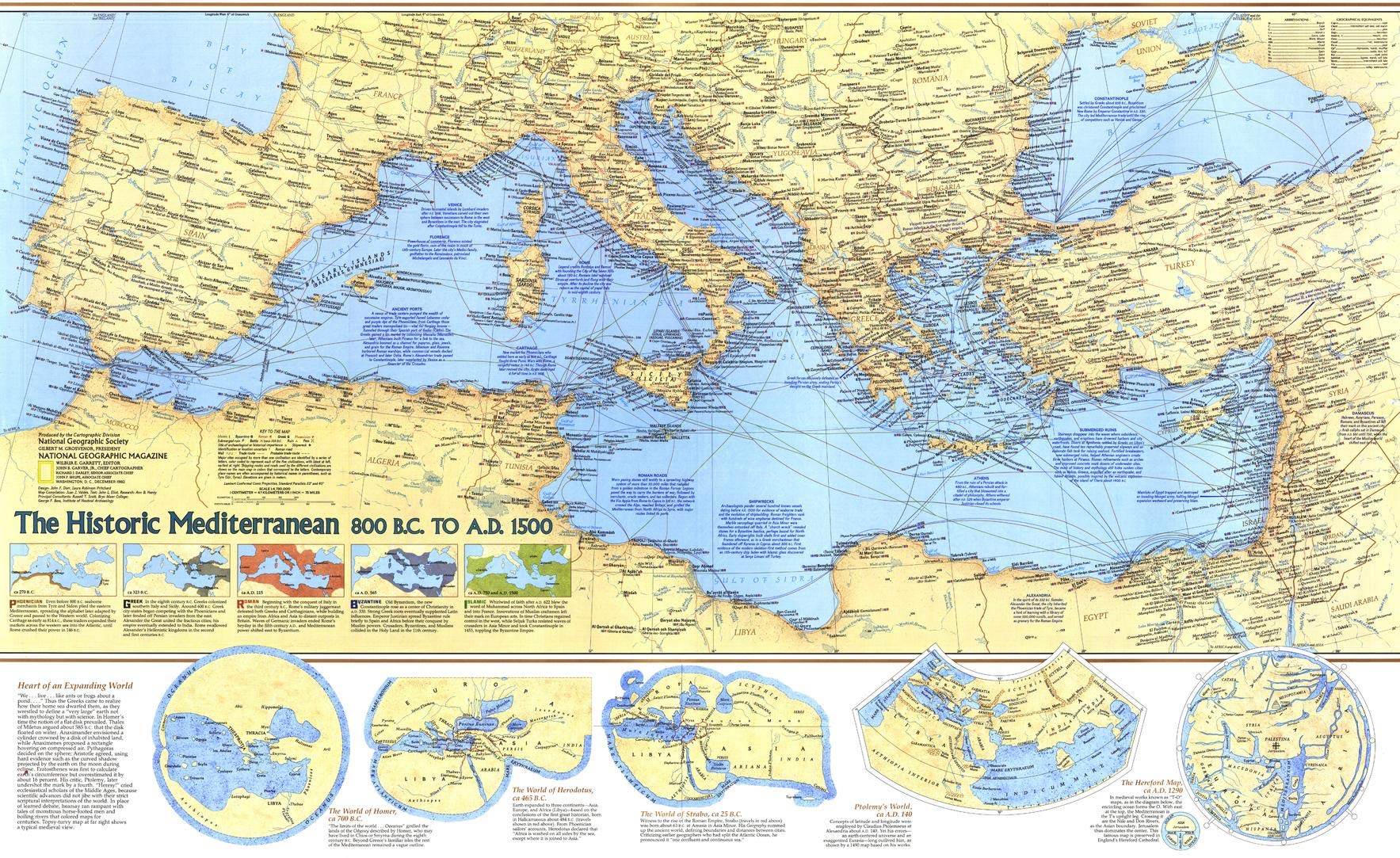
National Geographic: Historic Mediterranean Wall Map, 800 BC to AD 1500-36.75 x 22.5 inches - Laminated
Pirate History Poster, The Golden Age of Pirates, Art Map Poster, 24" x 36"
Great Maps: The World's Masterpieces Explored and Explained
Historic Maps of Kentucky
Historic Map - Augusta National Golf Club Course, 1954, Augusta National Golf Club - Vintage Wall Art 24in x 30in
Historic Maps and Views of Boston: 24 Frameable Maps and Views
Battles Map by Map (DK History Map by Map)
World War II Map by Map (DK History Map by Map)
National Geographic Complete National Parks of the United States, 3rd Edition: 400+ Parks, Monuments, Battlefields, Historic Sites, Scenic Trails, Recreation Areas, and Seashores
An Historical Map of Cambridge: University and County Town (Town & City Historical Maps)
Historic Map - Map of the World, 1587, Urbano Monte - Vintage Wall Art 24in x 24in
Historic Map - Dated Events Map of World War II Victory, 1945 - Unframed Vintage Wall Art - 24in x 11in
A History of the World in 500 Maps
Historic Pictoric Wall Map, World - Ocean Floors and Land Relief. 1976 - Vintage Wall Art - 24in x 16in
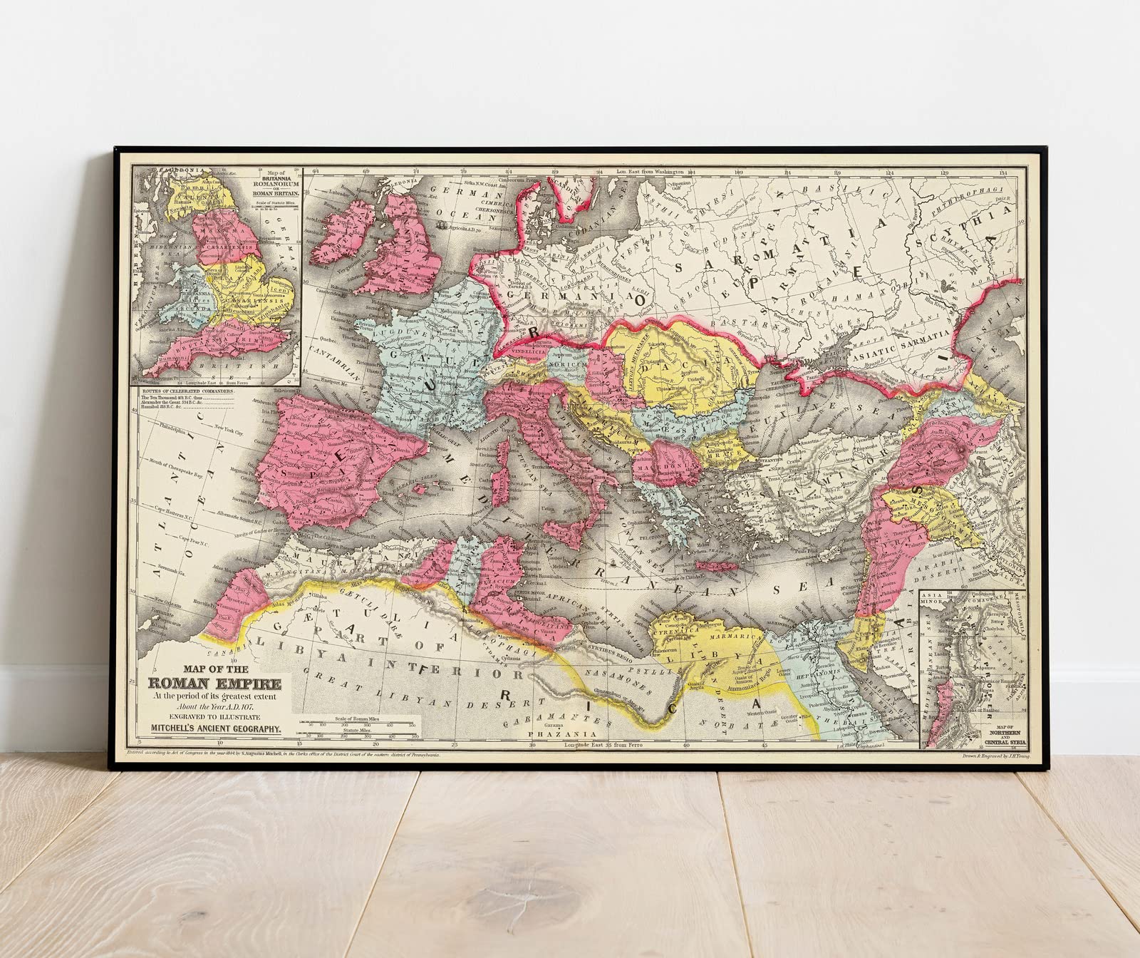
Historic Map - Map of The Roman Empire at The Period of its Greatest Extent About The Year A.D. 107, 1875 Classical Atlas - Vintage Wall Art - 36in x 24in
Charleston Historic District Illustrated Map
Savannah Historic District Illustrated Map.
Arizona, The Grand Canyon State, Recreation Map, 2024 Edition
Booth’s Maps of London Poverty, 1889: East & West London
Old World Map Tapestry, Vintage World Map Geographical Distribution Tapestry Wall Hanging, Brown Historical Atlas Educational World Map Poster for Wall Classroom Bedroom Living Room Office 60x40 Inch
A Map of Tudor London: The City and Southwark in 1520. Second edition
Classic World Map - Maps International - Front Lamination - A0 118.9 x 84.1 cm
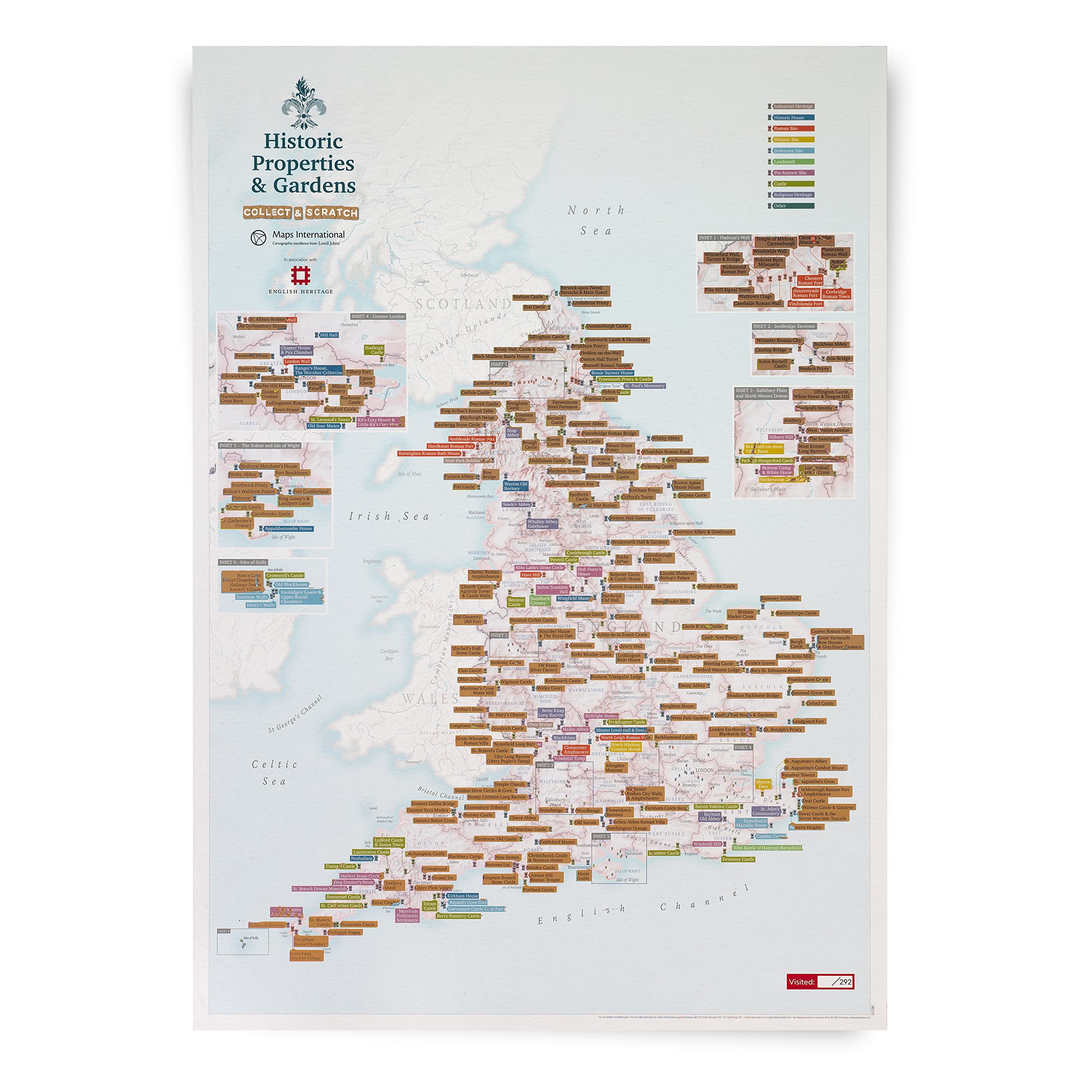
Maps InternationalScratch Off English Heritage Sites - Historic Properties & Gardens Print - Days Out - Places to Visit - Gift Poster - 42 (h) x 59.4 (w) cm
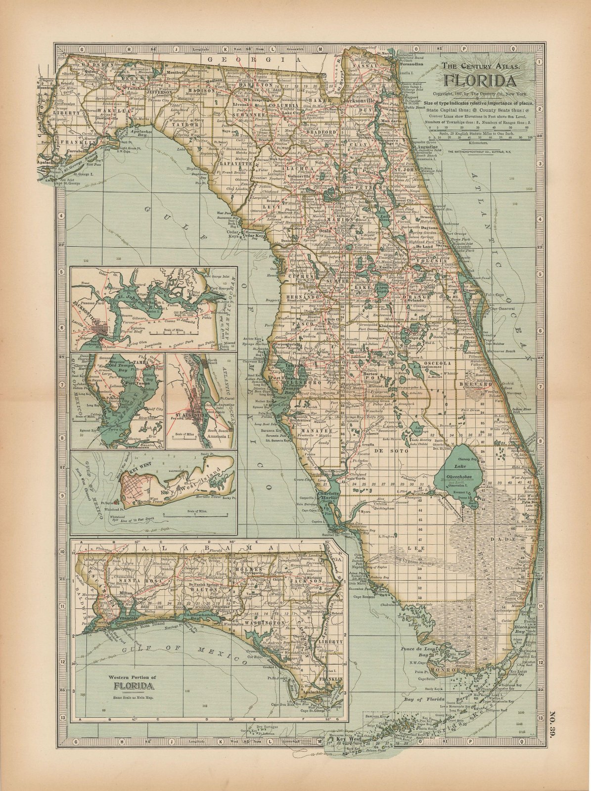
Historic Pictoric Map - Florida 1897 - The Century Atlas World - Vintage Poster Art Reproduction - 24in x 18in
Historic Maps and Views of London: 24 Frameable Maps
Historic Map - The State of Virginia from The Best Authorities, 1795, Matthew Carey - Vintage Wall Art 36in x 24in
Watervliet: Historic Maps
US and World Desk Map (13" x 18" Laminated) for Students, Home or Classroom Use by Lighthouse Geographics Office Product
Vintage World Map Tapestry, Antique Old Nautical Map of the World Wall Art, Historical Atlas Geography Retro Wanderlust Pirate Tapestry Wall Hanging for Bedroom Living Room Dorm, 60X40in, Brown Tan
Historic Map - World Atlas - 1873 German Empire. - Vintage Wall Art - 30in x 24in
Route 66, East by Butler Motorcycle Maps
Historic Map : CBS American School of The Air, Air Age Map of The World, A Polar Projection, 1943 - Vintage Wall Art - 24in x 30in
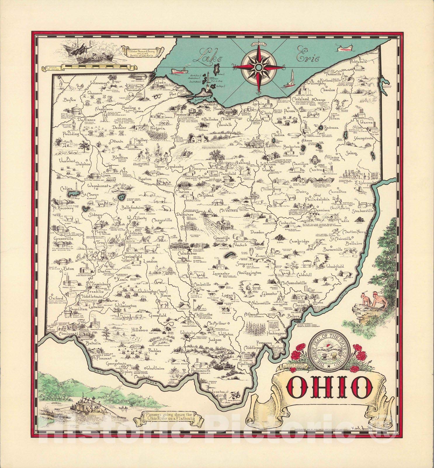
Historic Map - 1872 Historical map of The State of Ohio. - Vintage Wall Art - 18in x 24in
Historic Map : View of The Center of Paris, Taken from The Air. 1959 - Vintage Wall Art - 36in x 24in
Historic Map - Florida. (Inset: Western Part of Florida). Five Flags Have Flown Over Florida. 1953 - Vintage Wall Art - 18in x 24in
Historic Map - The Valley, Yosemite National Park 1946 - Vintage Wall Art - 24in x 18in
Batmerry Map Atlas USA Vintage Tapestry,Color Block Historic Map of The United States Wall Hanging Decoration Polyester Fiber White Ruffled Around for Dorm Room Bedroom Living Room, 51.2x59.1 inches
Doppelganger33 LTD Map Blaeu 1664 Europe Old Historic Large Replica Large Art Print Poster Wall Decor 18x24 inch
Historic Map - Wales [Gold Highlights!], 1611, John Speed - Vintage Wall Art 30in x 24in
Ireland Map (National Geographic Adventure Map, 3303)
Historic Pictoric Map : Negroland, adjacent countries., 1747, Vintage Wall Art : 30in x 24in
Historic Map - Newspaper Map, Face of Vietnam. 1965 - Vintage Wall Art - 16in x 24in
Poster Master Historic Map, Celestial Atlas Map - Earth, Sun & Moon Relationships 1869, 8x10 Unframed Art Print Poster, Vintage Wall Art, Great gift for Astronomy Fans
Historic Pictoric Map - Charleston Harbor, 1996 Nautical NOAA Chart - South Carolina (SC) - Vintage Wall Art - 32in x 44in
HISTORIX Vintage 1933 Long Island NY Map - 18x24 Inch Vintage Map of Long Island Wall Art - Old Long Island Sound Map - History Map of New York Poster - Historic State of New York Map Poster
Historic Map - A Vintage Map of Long Island, New York by Courtland Smith, 1933, Unframed Rustic Wall Art, Antique Reproduction Poster, Vintage Wall Art - 24in x 18in
Historic Pictoric Map : Africa, 1747, Vintage Wall Art : 24in x 20in
Historic Map : Ohio 1940 - Vintage Wall Art - 24in x 24in
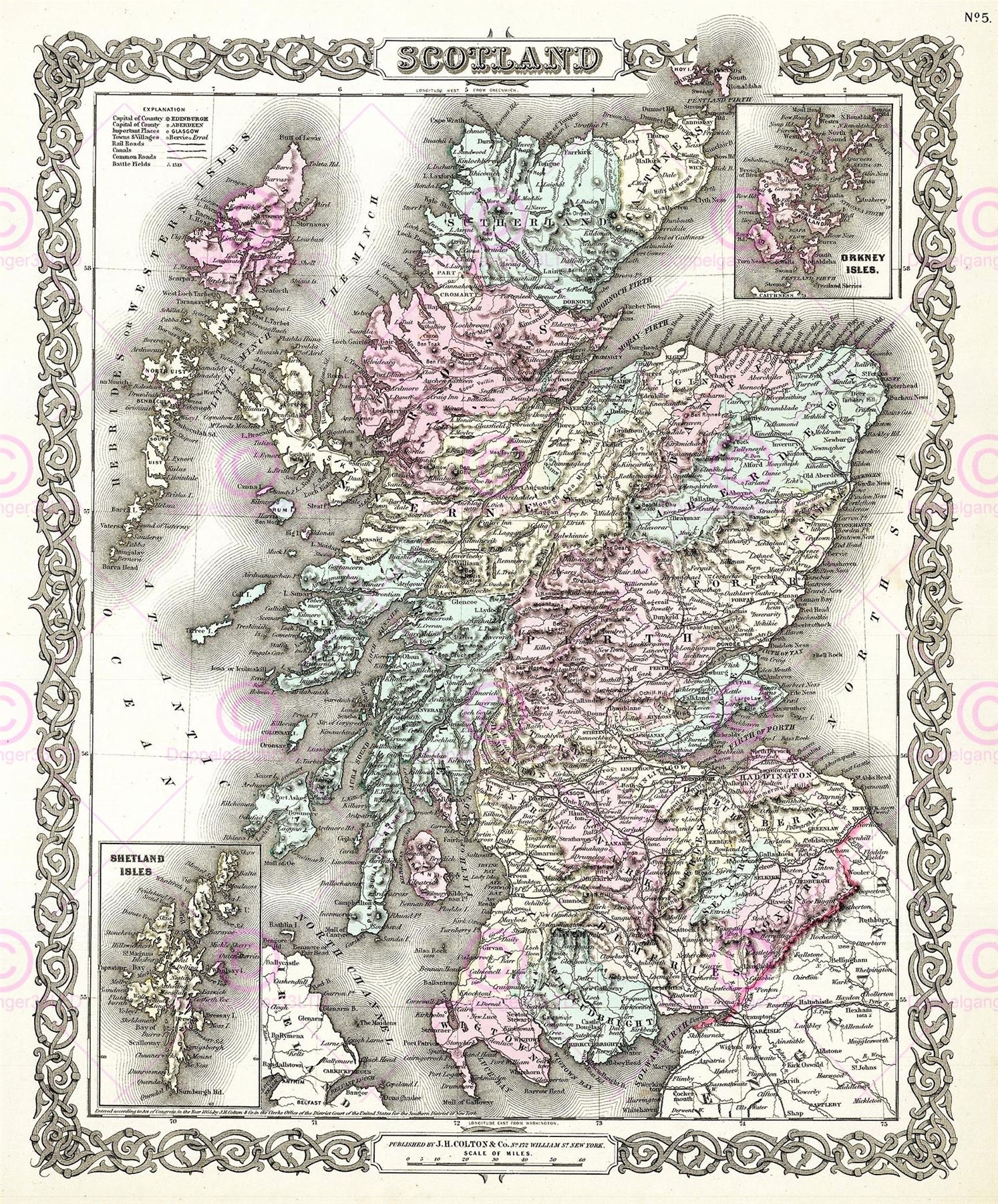
Doppelganger33LTD MAP 1855 COLTON SCOTLAND OLD HISTORIC LARGE REPLICA POSTER PRINT PAM0325
Southern France Map (National Geographic Adventure Map, 3314)
Winchester: British Historic Towns Atlas - Volume VI: 6
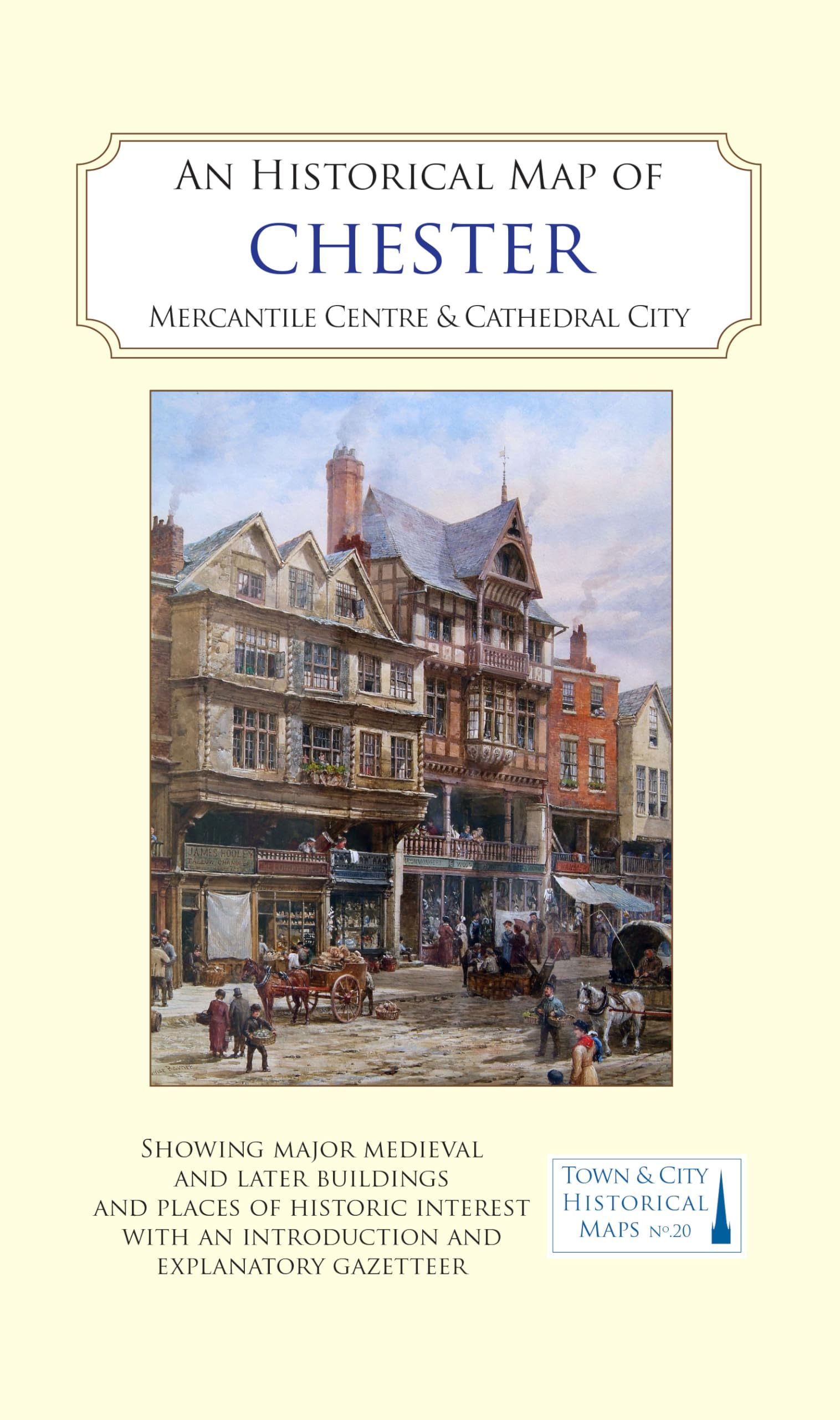
An Historical Map of Chester: Mercantile Centre and Cathedral City (Town & City Historical Maps series)
Salisbury A-Z Pocket Street Map
Major & Mrs Holt's Battle Map of The Somme (Map) (Holt's Battlefield Guidebooks) Map – Folded Map, 3 Oct. 2019
Streetwise Charleston Map - Laminated City Center Street Map of Charleston, South Carolina (Michelin Streetwise Maps)
Castles Map of Scotland: Explore Scotland’s ancient monuments (Collins Pictorial Maps)
Historic Map - Minneapolis, 1901, George F. Cram - Vintage Wall Art 24in x 36in
Great British Place Names Map | Funny Map & Guide | Marvellous Maps | Humour | British Gift | British Geography Map – Folded Map, 19 Nov. 2018


![Historic Map - Wales [Gold Highlights!], 1611, John Speed - Vintage Wall Art 30in x 24in](https://m.media-amazon.com/images/I/91wv+NkC6oL.jpg)